반응형
https://www.acmicpc.net/problem/17472
17472번: 다리 만들기 2
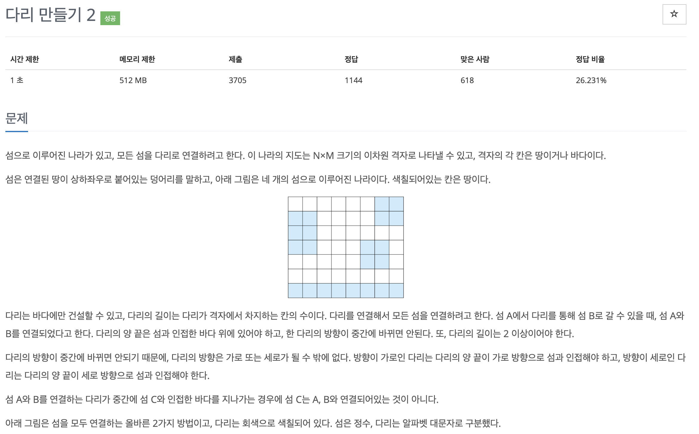
첫째 줄에 지도의 세로 크기 N과 가로 크기 M이 주어진다. 둘째 줄부터 N개의 줄에 지도의 정보가 주어진다. 각 줄은 M개의 수로 이루어져 있으며, 수는 0 또는 1이다. 0은 바다, 1은 땅을 의미한다.
www.acmicpc.net


백준에 삼성A형 기출문제로 분류되어 있다.
검색이 통제된 시험장 가서는 절대 못 풀 것 같은 문제.
bfs로 라벨링하고 최소 거리 구하는 것까지는 혼자서 처리할 수 있었는데, union find 코드는 예전에 내가 쓴 코드 다시 보고 만들어야 했다.
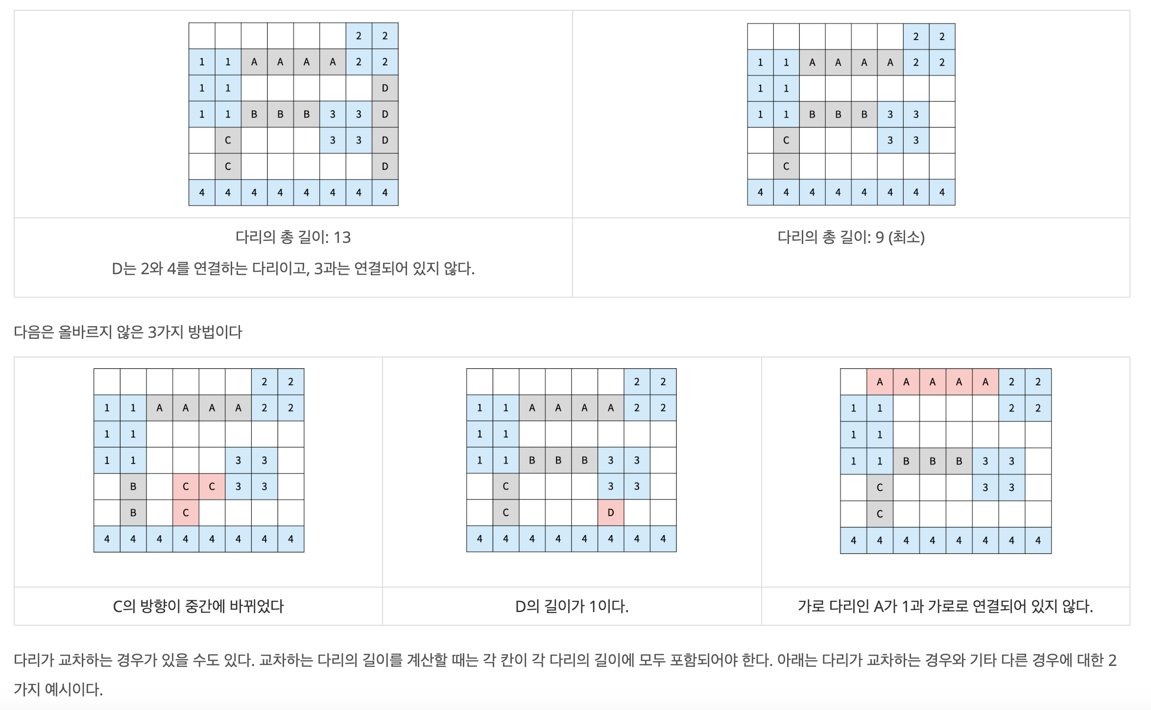
문제를 풀기 위해 생각해야 할 개념은 크게 세 가지다.
1. 각 섬을 구분해 준다. (섬별로 Labeling 해 준다고 보면 된다)
2. 각 섬을 연결하는 최소거리를 구한다.
3. 각 섬끼리의 최소거리를 토대로 섬과 섬을 연결해서, 모든 섬이 연결되면 최소거리의 합을 리턴하고 연결되지 않으면 -1을 리턴한다.
This file contains bidirectional Unicode text that may be interpreted or compiled differently than what appears below. To review, open the file in an editor that reveals hidden Unicode characters.
Learn more about bidirectional Unicode characters
import sys | |
import math | |
from collections import deque, defaultdict | |
r, c = map(int, sys.stdin.readline().split()) | |
maps = [] | |
for _ in range(r): | |
maps.append(list(map(int, sys.stdin.readline().split()))) | |
# 1. 각 섬별로 라벨링하기. | |
def bfs(start, maps, continent_name): | |
queue = deque() | |
queue.append(start) | |
dirs = [(0,1),(-1,0),(1,0),(0,-1)] | |
while queue: | |
y, x = queue.popleft() | |
# 해당 섬을 continent_name으로 라벨링한다. | |
maps[y][x] = continent_name | |
for dy, dx in dirs: | |
ny, nx = y+dy, x+dx | |
if 0 <= ny < len(maps) and 0 <= nx < len(maps[0]) and maps[ny][nx] == 1: | |
# 해당 섬을 continent_name으로 라벨링한다. | |
maps[ny][nx] = continent_name | |
queue.append((ny, nx)) | |
#2. 각 섬별로 최소거리를 구하는 함수 | |
def get_distance(maps): | |
# 최소거리를 저장하기 위해 dictionary를 생성하고, 기본값을 math.inf로 설정했다. | |
table = defaultdict(lambda: math.inf) | |
# iters = [가로, 세로] | |
iters = [maps, list(map(list, zip(*maps)))] | |
for each_maps in iters: | |
for y in range(len(each_maps)): | |
continent = None | |
checked = set() | |
for x in range(1, len(each_maps[0])): | |
# 섬 -> 바다로 바뀌는 경우, 섬의 마지막 좌표를 기억한다 | |
if each_maps[y][x] == 0 and each_maps[y][x-1] != 0: | |
continent = x-1 | |
# 바다 -> 섬으로 바뀌면서 이전에 통과한 섬이 있을 경우 | |
if each_maps[y][x] != 0 and continent is not None: | |
# 이전 섬과 현재 섬 거리를 계산한다 | |
distance = x - continent - 1 | |
# 거리가 2 이상이고, 현재 섬이 아직 거리계산을 하지 않은 섬일 경우 | |
if distance >= 2 and each_maps[y][x] not in checked: | |
# table에 섬 라벨링을 통일하기 위한 작업. | |
small = min(each_maps[y][continent], each_maps[y][x]) | |
large = max(each_maps[y][continent], each_maps[y][x]) | |
# 섬과 섬의 거리를 최솟값으로 업데이트한다. | |
table[(small, large)] = min(table[(small, large)], distance) | |
# 현재 섬의 라벨을 저장한다. 이전 섬 - 현재 섬 거리를 중복 계산하면 안 되기 때문 | |
checked.add(each_maps[y][x]) | |
return table | |
# union find에 필요한 함수 | |
def get_parent(x, parent): | |
if x == parent[x]: | |
return x | |
p = get_parent(parent[x], parent) | |
parent[x] = p | |
return p | |
def union_find(y, x, parent): | |
y = get_parent(y, parent) | |
x = get_parent(x, parent) | |
parent[x] = y | |
def get_min_distance(table, continents): | |
# 거리 짦은 순서대로 정렬 | |
table = sorted(list(table.items()), key = lambda x: x[1]) | |
result = 0 | |
# union_find의 parent들 | |
parent = {i:i for i in range(2, max(continents)+1)} | |
for (y, x), value in table: | |
# 두 섬이 '직접 / 간접' 어느 것으로든 연결되어 있지 않은 경우 | |
if get_parent(y, parent) != get_parent(x, parent): | |
# 두 섬을 union_find로 연결한다. | |
union_find(y, x, parent) | |
result += value | |
# 모든 섬이 연결되어 있다면, 모든 섬의 parent를 조사했을 때 값이 1개만 존재한다 | |
if len(set([get_parent(i, parent) for i in parent])) == 1: | |
return result | |
return -1 | |
# 섬 라벨링. 처음에 모든 섬이 1로 초기화되어 있어서 2부터 라벨링 | |
continent_num = 2 | |
for y in range(r): | |
for x in range(c): | |
if maps[y][x] == 1: | |
# 각 섬 라벨링 작업 | |
bfs((y, x), maps, continent_num) | |
# 라벨 + 1 | |
continent_num += 1 | |
# 섬 연결하는 최소거리 구하기 | |
table = get_distance(maps) | |
# 모든 섬이 연결되었는지 확인하기 | |
print(get_min_distance(table, set(range(2, continent_num)))) |
반응형
'프로그래밍 > 코딩테스트 문제풀이' 카테고리의 다른 글
[Python] 백준 15997. 승부 예측 (카카오 코드페스티벌 2018) (0) | 2020.02.07 |
---|---|
[Python] 백준 1976. 여행 가자 (0) | 2020.02.06 |
[Python] 백준 2573. 빙산 (0) | 2020.02.03 |
[Python] 백준 10799. 쇠막대기 (0) | 2020.02.01 |
[Python] 백준 2493. 탑 (0) | 2020.01.31 |